
Public Safety
Respond Effectively with Aerial Insights and Direct Aid Where It's Needed Most
Contact UsHow are drones used to protect and serve?

Immediate Intel
Respond to urgent missions with rapid aerial awareness

Coordinated Responses
Synchronize across teams with direct resources with live mission overwatch

Reduce Risk
Eliminate guesswork and act with assurance
What we offer
From the planning, to the flying, at Cloud City Drones we offer an unmatched level of support to get your department up and running

Consultation
100% FREE enterprise sales consultations. Our team of experts will help you find the perfect product to accomplish exactly what you're looking for.

Pilot Training
Situational training given by our team of experienced pilots. From the basics to advanced maneuvers we'll make sure you're well equipped tackle any mission.

Certification
In depth assistance with obtaining the proper certification and licenses for your department.

Post-Sale Support
Our ready to go support team can answer any technical related questions. We understand the need to have a fully operational system at all times.
Industry Leading Products
Regardless of the task at hand, Cloud City Drones provides a complete lineup of the highest rated industry tools to help get the job done.

MATRICE 300 RTK
The Matrice 300 RTK is a DJI commercial drone platform that takes inspiration from modern aviation systems. Offering up to 55 minutes of flight time, advanced AI capabilities, 6 Directional Sensing & Positioning, and more, the M300 RTK sets a whole new standard by combining intelligence with high-performance and unrivaled reliability.

MATRICE 30 SERIES
The Matrice 30 Series is a line of DJI portable drones that can integrate multiple sensors into one camera payload. It includes two models: Matrice 30 (M30) and Matrice 30T (M30T). The M30T has a thermal camera and a laser rangefinder sensor, while the M30 does not. Both models have a foldable design and an IP55 ingress protection.

MAVIC 3 ENTERPRISE SERIES
The Mavic 3 Enterprise Series redefines industry standards for small commercial drones. With a mechanical shutter, a 56× zoom camera, and an RTK module for centimeter-level precision, the Mavic 3E brings mapping and mission efficiency to new heights. A thermal version is available for firefighting, search and rescue, inspection, and night operations.

Zenmuse H20 Series
A powerful, integrated payload that unleashes advanced intelligent capabilities for DJI’s industrial drone platforms.
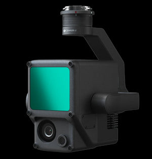
Zenmuse L1
The Zenmuse L1 integrates a Livox Lidar module, a high-accuracy IMU, and a camera with a 1-inch CMOS on a 3-axis stabilized gimbal.

Zenmuse P1
Verify data quality immediately post-flight by checking the position data and number of the images acquired, as well as RTK status and positioning accuracy.

Applications

Firefighting
Firefighters are quickly adopting next-generation aerial tools, ranging from multi-gas detectors to high-resolution thermal and visual cameras, enabling rapid and informed decisions when responding to volatile emergency situations
- Fly over buildings and obstacles, and see through smoke with thermal cameras to help prioritize targets
- Stream live video intelligence back to command centers to align teams and eliminate uncertainty
- Leverage high-resolution cameras to remotely monitor remaining threats and document damage for future analysis

Law Enforcement
Law enforcement agencies are adopting versatile aerial robots to aid in incident response, rapid mapping, and scouting to facilitate informed actions while also ensuring maximal safety for officers and bystanders.
- Provide incident commanders with accurate, real-time insight as missions unfold, empowering decisions to be made with confidence.
- Deploy to rapidly arrive on scene and gain immediate aerial insights.
- Hover above unfolding missions and live stream updates directly to command centers.
- Synchronize teams, eliminate uncertanty, and allow decisions to be made with confidence.

Rescue Services
First responders are turning to aerial solutions to aid in search and rescue missions. Deployed at land or sea, drones can efficiently scan vast areas and help pinpoint individuals in distress thanks to high-resolution digital and thermal sensors
- Scan wide areas and identify threats to victims and responders with high-resolution aerial imagery
- Elevate responders' perspective and bring search and rescue to new levels of efficiency
- At night, or in low-light conditions, leverage thermal sensors to locate missing persons who might otherwise be overlooked